|
One gets too exited about a project and tends to make all kinds of mistakes.. Well the links to the Porto Rico 1930 Georeferenciado project website were posted incorrectly in the original post. We were still making changes to the website. Here is are corrected links to the website.
www.prgeoref.org or http://prgeoref.weebly.com All comments are welcome. We have noted that the before and after page seems to load slowly sometimes. We will probably split that page into several in the future.
0 Comments
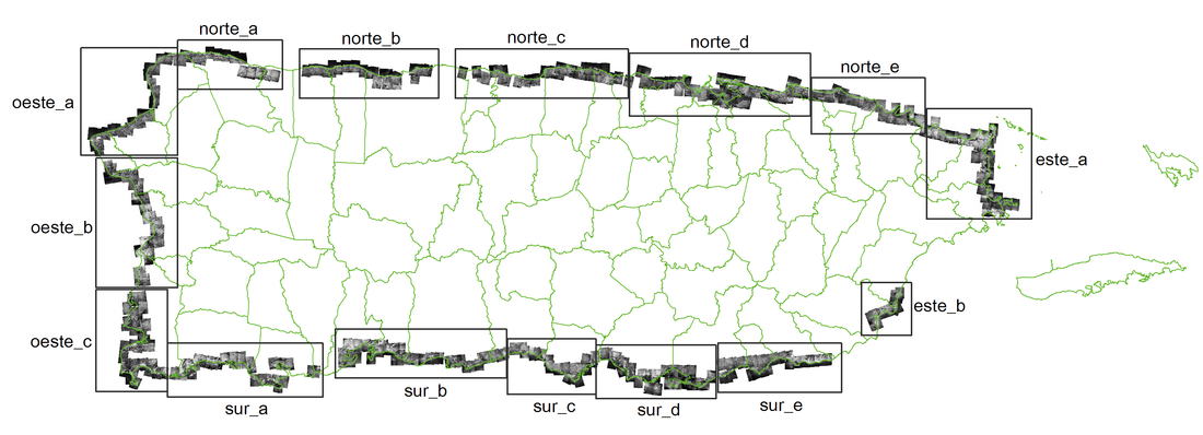 Have you ever wondered how the Puerto Rico coast looked like 90 years ago? The UPR at Mayagüez Center for Interdisciplinary Littoral Studies (CIEL) has just finished a project in which they took over 400 individual aerial photos and georeferenced them to create a series of mosaics of the coast. These are available to the public both in GIS (ECW format) and non GIS (JPG) formats. Most of the work was performed by UPRM students with Tania Lopez Marrero's guidance.
Please visit the new collaboration web site. www.prgeoref.org If you want to see some examples of how the Puerto Rico coast has changed, Visit this page. http://prgeoref.weebly.com/antes-y-ahora.html Great job CIEL! Just a quick note on a new Geoinformática, Inc. initiative. We are currently developing a white paper with ideas to write one or several proposals around the Mayagüez Bay watershed and surrounding area. Some of the topics are:
Co-management of agricultural and natural land Forest and Ecosystem Services Community Development MicroBusiness Initiatives App Development for Community Development GeoDatabase Development (Field Data Collection) Water Quality Issues Local General Health Indicators Please contact me should you want to be part of the initiative. I have published 2 short documents in spanish. One is about open source GIS software packages and the other one is about on-line GIS data availability. Both documents were prepared as part of my ongoing collaboration with the University of Puerto Rico Interdisciplinary Litoral Studies Center (UPR-CIEL). Visit their web site, it is pretty cool too. https://ciel-uprm.org/. Both are available on the CIEL web site.
Well. Manifold has taken its sweet time with its release schedule. I think that the last new product they published was in 2011, then went silent. This last week they released Radian Studio after a year of beta testing. They call the product a spatial engineering tool not a GIS, and this is true. The best way to understand the uses and purpose of the product is to read their FAQ.
http://www.manifold.net/info/radian_faq.shtml Some highlights of the product. If you do not want to read their FAQ
Bottom line. If you want to be at the cutting edge of GIS software and are ready to learn RDBMS programming and tools by all means try Radian Studio. If you use Manifold 8 GIS or any other GIS package, and are not planning to use an RDBMS as your GIS data storage strategy or do not need more speed. I suggest that you wait for Manifold 9. My next post will be about how Radian Studio will change my life (for good or bad) Cheers |
Antonio González-ToroI write about GIS and Geographical topics. Archives
October 2020
Categories |


 RSS Feed